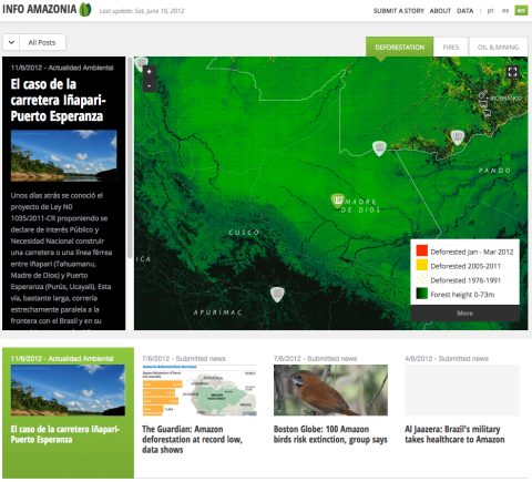
Infoamazonia covered a story about forest fires in Bolivia. Click on the photo above for more information.

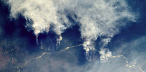
This satellite image from NASA shows large columns of smoke over the Brazilian Amazon during the dry season of 2011. (Photo credit: MODIS, Aqua Satellite, NASA)

Infoamazonia covered a story about forest fires in Bolivia. Click on the photo above for more information.
The Amazon rainforest is the most pristine ecosystem on Earth. Stretching across nine countries, the rainforest harbors millions of plant and animal species. Despite the important role the rainforest plays in the health of the South American and global environment, little information is available about threats to the area’s survival. Over the last 40 years, deforestation has affected about 10% of the region’s two million square miles. New projects underway such as roads, hydroelectric dams and oil fields threaten even more rapid destruction of this delicate ecosystem.

Infoamazonia covered a story about forest fires in Bolivia. Click on the photo above for more information.
NGOs and news organizations across the nine-country Amazon rainforest region have agreed to use the platform to share data and stories. As InfoAmazonia adds more data and visualization tools, it will become the chief hub of reliable, local and regional information about the rainforest that can be mapped and downloaded. The public will be invited to submit web links to news stories about the Amazon. The links will be placed on maps and given context with information on such issues as deforestation and forest fires.
Because the data, satellite images and other information gathered by journalists, NGOs and citizens will be updated frequently, the platform will be a visual and graphic log of development, deforestation, forest fires, mining and other threats to the rainforest. As part of its mission, InfoAmazonia also will promote open data to enrich the quantity and quality of information available about the rainforest. The aim: to stop and hopefully reverse environmental damage to this precious natural resource.
Over the last three months, I have been developing the website as a Knight International Journalism Fellow. The project began as a partnership between the Brazilian environmental news agency O Eco and Internews, with additional support from the Climate and Development Knowledge Network. U.S.-based Development Seed designed the platform’s maps and publishing system.
Editor's note: NationalGeographic.com says InfoAmazonia "combines the descriptive power of cartography with timely news and reports about environmental threats to the region."